1Mind1Spirit
Literal lunatic
Yes, ratio... Of the diameters of the sun, the moon and the earth! Please pay attention!
I changed it hot rod.
Still no on the chandelier crapola.
Yes, ratio... Of the diameters of the sun, the moon and the earth! Please pay attention!
I apologise, I'm going after this the wrong way, here. Alright, try this instead. Grab a lamp, place it about a foot to a foot and a half away from one wall, turn it on, and (with the shade off) hold your finger a few inches away from it, where the shadow of your finger is barely visible.I changed it hot rod.
Still no on the chandelier crapola.
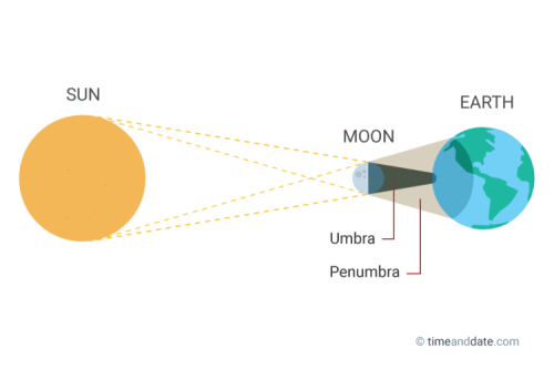
Also no matter how close or far away from the light source or back drop the object (moon) is, it can never cast a shadow smaller than itself.
False
")
False
The umbra will never be or appear smaller than the object itself.
It will always appear smaller than the penumbra.
Try it on a smaller scale moving the object closer to the back drop and I guarantee you it never appears smaller than when you get it next to the back drop.
Get a big flashlight and hold a penny in front of it.
Start moving the penny toward the wall.
I did it before I made my first post to rightly.
It's why I'm not budgin'.
Edit: There is a point where you can see the umbra inside the penumbra, it's pretty cool but not smaller than the actual object.
Here's what you are missing:
The sun is approx. 850,000 miles in diameter.
It projects light that size in all directions.
If we consider only the light coming in the direction of the earth, it projects a beam of light across the solar system the same size, near it or far away from it. When that beam of light passes by the earth, it is still 850,000 miles in diameter, but the earth is only 25,000 miles in diameter.
Imagine you are in a space ship on the dark side of the earth. As you move farther away from the earth and sun, because the sun is much larger, the shadow the earth would cast becomes smaller. You will have more difficulty staying in a place where the sun (to you) is covered and, eventually you will see a ring of light around the earth in your rear view mirror that will increase the farther away you get away from the earth. This is because you have passed the point where (to you) there is an umbra. The light from one edge of the sun is illuminating the opposite side and so forth at any point around the circle. Eventually the earth will appear as only a small spot on the sun.
You can prove this to yourself by closing one eye and putting your fist close in front of the open eye. Now back your head away without moving your fist. Whereas you could not see the light from your monitor to begin with, as you back your eye away, the light from your computer begins to come into view. It's all about the relationship of the object sizes and your vantage point.
The guy you're calling a lunatic already did the work.
I see you didn't watch the video about the map either.
He has Gleason's book and patent and went into way more detail than you did.
This blogger discusses flight paths, (a little bit), in association with maps and at the same time also proves the same thing I have been saying herein: that the flat-earthers are for the most part unknowingly and unwittingly using a 2D azimuthal globe earth map to supposedly prove their theories. :rotfl:

http://flatearthdeception.com/maps-prove-the-flat-earth-deception/


The equipment is still on the roof of a house I no longer inhabit.Show me how you did that? Saying it does not prove it.
Show me a pictures of your equipment. You have a camera don't you?
I'm not saying you didn't, but I hope you understand this needs verification.
--Dave
The angle for the sun is built on a plane as if the earth was flat and a circle.
View attachment 26270
Since the distance of the sun is not a factor in its angle it is presumed the arc of the sun's path is the opposite of what would be expected if the earth was flat from the north compared to the south.
All anyone "really" sees, from any location on earth, is the sun rising and setting as it moves across the sky. No one anywhere sees any arc or spends all day trying to observe it.
The idea that there is an opposite arc from north to south is not proven by the angles of the sun. The opposing arc argument presumes a globe but does not prove it.
Everywhere on earth we see the sun move across the sky from lower in the sky to higher in the sky, closer to us and further away from us through the seasons.
--Dave
I'm going over the information you gave me with the time I have. I still work everyday, but i'm retiring and will have a lot more time for this in a month.
Your claim that everything your saying is absolutely truth, end of story, is not a debate.
I haven't heard from "everyone living in the southern hemisphere" so I don't know what they "all" see.
Have you nothing to say about my objections other than I've lost the argument?
Assuming the earth is flat in order to get the angle of the sun contradicts the earth is a globe.
It's these funny contradictions that keep me from accepting globe earth heliocentrism. It seems contradiction don't bother you and many others.
--Dave

The equipment is still on the roof of a house I no longer inhabit.
It doesn't need any verification from me. You can just accept my word. After all, I have been nothing but honest with you up to this point, so there is good evidence to support my reliability in this matter.
Stuart
When you say, "Assuming the earth is flat in order to get the angle of the sun contradicts the earth is a globe" it is yourself doing the assuming. In the diagram below the plane or circle is only for calculation purposes and represents the 90 degree local latitude upon which the observer is standing, or the house, or building, or location, or whatever. This kind of geometry is used every day all over the world in building construction because it is necessary to know the path of the sun for solar heating or solar heat avoidance purposes. It does not mean the drawing is assuming a flat earth but rather using the circle or disc as a plane of reference to calculate the path of the sun.
Here is a link to an architectural site which uses such geometry:
https://www.iesve.com/software/case-studies/info?building=TLC-Engineering-for-Architecture&id=2880
Here is a Wiki article discussing the architectural uses of this geometry, which also goes into some depth explaining what I have said previously herein: how the path of the sun is a reverse arc in the southern hemisphere compared to what is seen in the northern hemisphere. If builders and architects need such things to properly lay out the buildings and stadiums they are about to build then it should be fairly clear that this is not some conspiracy.
https://en.wikipedia.org/wiki/Sun_path
From the article:
Effect of the Earth's axial tilt
Sun paths at any latitude and any time of the year can be determined from basic geometry.[4] The Earth's axis of rotation tilts about 23.5 degrees, relative to the plane of Earth's orbit around the Sun. As the Earth orbits the Sun, this creates the 47° declination difference between the solstice sun paths, as well as the hemisphere-specific difference between summer and winter.
In the Northern Hemisphere, the sun path near to the winter solstice (November, December, January) rises in the southeast, transits the celestial meridian at a low angle in the south (more than 43° above the southern horizon in the tropics), and then sets in the southwest. It is on the south (equator) side of the house all day long. A vertical window facing south (equator side) is effective for capturing solar thermal energy. For comparison, the sun path near the winter solstice in the Southern Hemisphere (May, June, July) rises in the northeast, peaks out at a low angle in the north (more than halfway up from the horizon in the tropics), and then sets in the northwest. There, the north-facing window would let in plenty of solar thermal energy to the house.
In the Northern Hemisphere, the sun path near to the summer solstice (May, June, July), the Sun rises in the northeast, peaks out slightly south of overhead point (lower in the south at higher latitude), and then sets in the northwest, whereas in the Southern Hemisphere the sun path near the summer solstice (November, December, January), the Sun rises in the southeast, peaks out slightly north of overhead point (lower in the north at higher latitude), and then sets in the southwest. A simple latitude-dependent equator-side overhang can easily be designed to block 100% of the direct solar gain from entering vertical equator-facing windows on the hottest days of the year. Roll-down exterior shade screens, interior translucent-or-opaque window quilts, drapes, shutters, movable trellises, etc. can be used for hourly, daily or seasonal sun and heat transfer control (without any active electrical air conditioning).
Everywhere around the world during the equinoxes (March 20/21 and September 22/23) except for the poles, the sun rises due east and sets due west. In the Northern Hemisphere, the equinox sun peaks in the southern half (about halfway up from the horizon at mid latitude) of the sky, while in the Southern Hemisphere, that sun peaks in the northern half of the sky. When facing the equator, the sun appears to move from left to right in the Northern Hemisphere and from right to left in the Southern Hemisphere.
The latitude (and hemisphere)-specific solar path differences are critical to effective passive solar building design. They are essential data for optimal window and overhang seasonal design. Solar designers must know the precise solar path angles for each location they design for, and how they compare to place-based seasonal heating and cooling requirements.
In the U.S., the precise location-specific altitude-and-azimuth seasonal solar path numbers are available from NOAA – the "equator side" of a building is south in the Northern Hemisphere, and north in the Southern Hemisphere, where the peak summer solstice solar altitude occurs on December 21.
https://en.wikipedia.org/wiki/Sun_path
The paths of the sun are definitely not a conspiracy.
You personally watched the sun "all day" and observe an arc that actually curved in conformity with an globe like daqq illustrates here? I know he's not trying to illustrate this to exact scale but I get his point.
View attachment 26272
--Dave
To everyone
There have been good arguments made for globe earth.
There have been good arguments made for flat earth.
I personally will judge all arguments from both sides for logical/rational integrity. I have done this with every topic I have studied. For me the existence of God wins this way, freewill wins this way, openview wins this way, creationism wins this way. For many of you, globe earth heliocentrism wins this way for others flat earth wins this way, but I have not made up my mind on this because there are arguments from flat earth that make me doubt the heliocentrism I once never questioned.
What is the horizon?
Globe earth has a different meaning for the word than flat earth. The scales are not important, the illustrations below make their point. We can't make arguments that make sense to the opposing view if we are using the same word differently so lets understand this difference and the problem it produces.
Is the horizon the bulge of the curved earth we look slightly down at in the distance?
View attachment 26275 View attachment 26276
Or is the horizon the farthest we see in the distance as the flat earth rises to our eye level?
View attachment 26277
Is the globe position a rejection that a flat plane will rises to our eye level?
I want to hear from the heliocentrics about this before I make a conclusion.
--Dave
What, verification that I have done an experiment that repeats the well-established work of others before me? Science requires no such verification. But that is the power of science: in principle at least, anyone can repeat an experiment for themselves and expect to get the same results, and if those results are not achieved then question the hypothesis or theory. I got entirely consistent results with the model that has the sun setting at a different place along the horizon each day, a phenomenon entirely explained by a model of a global earth orbiting the sun, slightly tilted on its rotational axis, and according to Newton's Laws of motion. I have never seen how a flat earth model explains that change in setting position. How does it?I can't question your personal opinion, but this is science and verification is required.
--Dave
Dave, if the Earth is a flat disk, how could it possibly rise to our eye level?
Once again, you can stop with the IDIOTIC photographic arguments. It convinces no one other than those who haven't the faintest idea how cameras work. With the right wide angle lens you can make the same horizon look convex, concave or flat all from the exact same location. It's simply a matter of camera angle and type of lens used.
By the way, why on Earth would the comptrollers of the worldwide conspiracy ever permit a photograph of the flat earth to survive long enough to make it to the internet. Aren't you afraid for your life for having posted such unassailable evidence that "they" have been lying to us?
And the moons shadow isn't 100 miles wide. OH Lord! How can people be so uncontrollably gullible and stupid?
The apparent size of the Sun and Moon are almost exactly the same but the Sun is very far away and so you don't have to be out of alignment with the two objects by very much to be able to see a portion of the Sun past the edge of the Moon. If the Moon were closer to the surface of the Earth, its umbral shadow (path of totality) would be larger. If, on the other hand, it were much further away at all, then there would be no umbral shadow on the surface of the Earth whatsoever because we could see the edge of the Sun all the way around the Moon. In other words, the umbral shadow is pretty much as small as it could possibly get without going away completely. As such, the fact that the umbra is 100 miles across is proof that the flat-earth stupidity about both objects being only a few thousand miles away is flatly falsified. No way possible for the Moon to cast the shadow that it casts unless the Sun is very much further away than the Moon is and WAY WAY further away than the flat-earthers suggest.
Prediction: This argument, which is sufficient to convince anyone who is being the least bit honest, will be ignored entirely. No response of any substance will be offered and it will not move a single flat earther one inch away from his ridiculous delusion.
Clete
When you say, "Assuming the earth is flat in order to get the angle of the sun contradicts the earth is a globe" it is yourself doing the assuming. In the diagram below the plane or circle is only for calculation purposes and represents the 90 degree local latitude upon which the observer is standing, or the house, or building, or location, or whatever. This kind of geometry is used every day all over the world in building construction because it is necessary to know the path of the sun for solar heating or solar heat avoidance purposes. It does not mean the drawing is assuming a flat earth but rather using the circle or disc as a plane of reference to calculate the path of the sun.
Here is a link to an architectural site which uses such geometry:
https://www.iesve.com/software/case-studies/info?building=TLC-Engineering-for-Architecture&id=2880
Here is a Wiki article discussing the architectural uses of this geometry, which also goes into some depth explaining what I have said previously herein: how the path of the sun is a reverse arc in the southern hemisphere compared to what is seen in the northern hemisphere. If builders and architects need such things to properly lay out the buildings and stadiums they are about to build then it should be fairly clear that this is not some conspiracy.
https://en.wikipedia.org/wiki/Sun_path
From the article:
Effect of the Earth's axial tilt
Sun paths at any latitude and any time of the year can be determined from basic geometry.[4] The Earth's axis of rotation tilts about 23.5 degrees, relative to the plane of Earth's orbit around the Sun. As the Earth orbits the Sun, this creates the 47° declination difference between the solstice sun paths, as well as the hemisphere-specific difference between summer and winter.
In the Northern Hemisphere, the sun path near to the winter solstice (November, December, January) rises in the southeast, transits the celestial meridian at a low angle in the south (more than 43° above the southern horizon in the tropics), and then sets in the southwest. It is on the south (equator) side of the house all day long. A vertical window facing south (equator side) is effective for capturing solar thermal energy. For comparison, the sun path near the winter solstice in the Southern Hemisphere (May, June, July) rises in the northeast, peaks out at a low angle in the north (more than halfway up from the horizon in the tropics), and then sets in the northwest. There, the north-facing window would let in plenty of solar thermal energy to the house.
In the Northern Hemisphere, the sun path near to the summer solstice (May, June, July), the Sun rises in the northeast, peaks out slightly south of overhead point (lower in the south at higher latitude), and then sets in the northwest, whereas in the Southern Hemisphere the sun path near the summer solstice (November, December, January), the Sun rises in the southeast, peaks out slightly north of overhead point (lower in the north at higher latitude), and then sets in the southwest. A simple latitude-dependent equator-side overhang can easily be designed to block 100% of the direct solar gain from entering vertical equator-facing windows on the hottest days of the year. Roll-down exterior shade screens, interior translucent-or-opaque window quilts, drapes, shutters, movable trellises, etc. can be used for hourly, daily or seasonal sun and heat transfer control (without any active electrical air conditioning).
Everywhere around the world during the equinoxes (March 20/21 and September 22/23) except for the poles, the sun rises due east and sets due west. In the Northern Hemisphere, the equinox sun peaks in the southern half (about halfway up from the horizon at mid latitude) of the sky, while in the Southern Hemisphere, that sun peaks in the northern half of the sky. When facing the equator, the sun appears to move from left to right in the Northern Hemisphere and from right to left in the Southern Hemisphere.
The latitude (and hemisphere)-specific solar path differences are critical to effective passive solar building design. They are essential data for optimal window and overhang seasonal design. Solar designers must know the precise solar path angles for each location they design for, and how they compare to place-based seasonal heating and cooling requirements.
In the U.S., the precise location-specific altitude-and-azimuth seasonal solar path numbers are available from NOAA – the "equator side" of a building is south in the Northern Hemisphere, and north in the Southern Hemisphere, where the peak summer solstice solar altitude occurs on December 21.
https://en.wikipedia.org/wiki/Sun_path
The paths of the sun are definitely not a conspiracy.


